|
There are many places to grab a great run in the Billings area. Whether you like road runs through the city, highway runs in the country, or trail runs featuring spectacular scenary, the area has something for you. Below you will find some suggested routes for local runs. Some of these are used by our cross country team.
|
| Route |
Description |
Mileage |
Picture Link |
| Zimmerman Park |
This country park atop the rimrocks is located about 2 miles west of the airport on Highway 3. There is a parking lot just off the highway. The miles of parallel trails wind along the edge of the rims and you will find them at different elevations. There are a fair number of hills in the single track trail. Portions of the trails are made up of the large rimrock but the majority is dirt. The trail system hooks up with other trails that extend outside the park boundaries. Google satellite view
|
Varies |
Go to the
Photo Gallery |
| Swords Park |
Known as the Black Otter run by the cross country team, this recently remodeled park features a great view of the city as you follow the rims from the airport to the east end above the Metra. Starting from Pioneer Park, go over to 30th Street North and head up through the Montana State University campus. Once you get to Rimrock Drive, pick up 27th and head up to the airport and then head east along the top of the rims. The road will take you past Yellowstone Kelly's grave site and eventually to an intersection at the bottom of the rims with 6th Avenue Bypass. Turn right and follow the base of the rims until you're on 6th Ave. North and follow it past North Park. Cut though the park and continue west on 8th Ave. North. Cross 27th Street (watch for traffic) and you'll be on Ave. C which will take you back to Pioneer Park. Google Maps
|
8 |
|
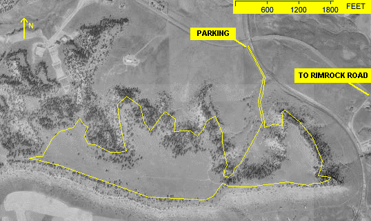
| Phipps Park |
Also known as Phipps Diamond X Ranch, this 350 acre city park is located outside the city limits on Molt Road about 4 miles west of the city. To get there, take Rimrock Road west to where it turns north and then west again. You'll go under as railroad bridge and see the parking lot immediately on your left. There is an extensive 27-hole disc golf course there featuring some very rugged terrain. For the runner, there are a variety of trails that feature some outstanding panoramic views of Yellowstone Valley and Echo Canyon. There is a trail along the base of the rims that is about 4 miles out and back from the parking lot. Just take the main trail and keep to the left, or east side of the rims. To get in more distance, and some hill work, follow the main trail, a rocky road, up through the center of the canyon. Once you've conquered that serious hill, there is a single track trail that follows the edge of the rims around the entire park. The south side is fairly exposed but provides great views of the Pryor and Beartooth Mountains. Once you loop back, look for the trail that veers north and follows the north edge of the rims. This portion is fairly well-wooded. Depending on the time of year you can encounter all types wild life: turkeys, rabbits, rattlesnakes, deer, and antelope.
Google satellite view
Aerial Photo with 4 mile course marked.
|
4 or more |
Go to the
Photo Gallery |
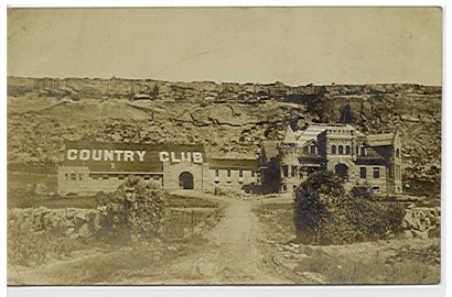
Country Club Circle
(Myers Trail)
to Zimmerman Trail |
This is a portion of a longer trail system that runs along the edge of the rimrocks that tower over the north side of the city. It is half trail run, half road run. You can start from the intersection of West Country Club Circle and Rimrock Road, which is about 1/2 mile west of 17th Street West. (Click here for street map.) I know, there is no country club there, but there used to be (click for a picture of it). Run uphill, north, into the residential neighborhood a few blocks. When you get to the top of the hill, just before the street veers right, look for the trail on your left. Follow the single track trail to the top of the rims. Parts of the trail are rocky and when you get into the trees there are a few sections where you'll have to climb a rock or two. Once you get near the top, the trail will split with one track headed east and one west. Stay to the left and follow the westbound trail. The first 1/2 mile or so is over the smooth rocks that make up the top of the rims, but eventually turns into a dirt trail. You'll be running just in front of homes built on top of the rims and in one portion you'll have to cross private property. This is well posted and the owner just asks that you keep to the trail. The view is great and the trail avoids getting too close to the edge of the rims. Once you get near the end of the trail you'll come to a small coulee that separates you from Zimmerman Trail (a paved roadway). If you watch for it, there is a trail that desends, steeply, on the east side of the road, dropping you on to the cul-de-sac at the intersection of Leeann Blvd. and Forsythia Blvd. Click for a street map. Your other option is to run back down to Rimrock Road on Zimmerman Trail. This roadway is very narrow and there is not much of a shoulder to shield a runner from the cars. Either way, you'll eventually end up back on Rimrock Road which you can follow back to your starting point.
Click here for an aerial view with the course marked.
|
about 4 |
Go to the
Photo Gallery |
Country Club Circle
(Myers Trail)
MSU-B |
This run is similar to the one above except when you get to the top of the rims, turn right (east) and follow the rims until the trail ends adjacent to the airport. At that point, step down the the highway (27th Street) and you will find a single track trail that runs next to the guard rail and heads down the hill. When the trail ends, follow the sidewalk to your right and you'll be heading west on Rimrock Road. A good portion of the trail is made up of very uneven rock so your ankles will get a good workout. Parts of the trail come very close to the edge of the rims and the drop off is deadly. If heights get to you, head up the embankment on the north side of the trail and there is a very wide, graveled parking area that you can run on instead.
Click here for an aerial view with the course marked.
|
about 6 |
Go to the
Photo Gallery |
| Poets Run |
This is a cross country run we do early in our training. It's all on city streets and gives us a bit of hill work. We start in Pioneer Park, head up Virginia Lane and just past Poly Drive we cross the ditch and turn left (west) on Woodland Drive. From there we run through the streets between Woodland and Highland Park Drive from Virginia Lane to Highwood Drive. Then we run back on the same course in reverse. Why is it called the "Poets" run? Those streets we run up and down are Longfellow, Irving, Raymond, Whittier, and Emerson.
Click here for an aerial view with the course marked.
|
4.1 |
|
| Two Moon Park |
This park along the Yellowstone River in Billings Heights features several miles of flat trails. There is an outer loop that is about 2 miles and some inner trails that provide alternative ways to get to the northeast of the park. There is a parking lot at the bottom of the entry road, but there is one at the top of the park as well. Across the road from the upper lot is a switchback trail that will take you down to the park without having to run on the gravel road.
To get here, go out Main Street, past the Metra, and turn right on Lake Elmo Drive (you'll see Target.) Follow the road until it curves to the left it becomes Bench Blvd. You'll see the Centennial Ice Arena on the right and a sign for Two Moon Park. Turn right and go just past the arena.
Click here for an aerial view of the park.
|
4 plus |
Go to the
Photo Gallery |
|